UPDATE: 7:20PM AUG.22 — The Madison County Sheriff’s Office has issued an evacuation warning for residents in the Upper Wisconsin, Noble, and Indian Creek areas. While no official evacuation order is in place, officials urge residents to be prepared to leave if conditions worsen. Law enforcement will conduct door-to-door notifications if an evacuation becomes necessary. For assistance, call 1-800-RED CROSS or the county’s non-emergency line. A shelter location will be announced once it is ready.
UPDATE: 1:54PM AUG. 22 — The Bivens Creek fire is at 2,219 acres with 0% containment. The Cloudrest fire has increased to 1733 acres, also at 0% containment.
An infrared flight has given fire managers clearer data on the Cloudrest and Bivens Creek fires as shifting northeast winds Friday threaten to drive flames into new terrain. Crews are adapting tactics to protect communities while an Air Resource Advisor works with Madison County Public Health to monitor smoke expected to linger in lower valleys.
Cooler weather and higher humidity offer slight relief, but dry timber will keep fire activity high, including at night due to a thermal belt.
Hotshot crews on Cloudrest are reinforcing lines in South Willow Creek to slow spread toward Pony, while scouting new lines in Indian Creek. At Bivens Creek, firefighters are advancing containment in Ramshorn and South Meadow creeks with aerial and ground support.
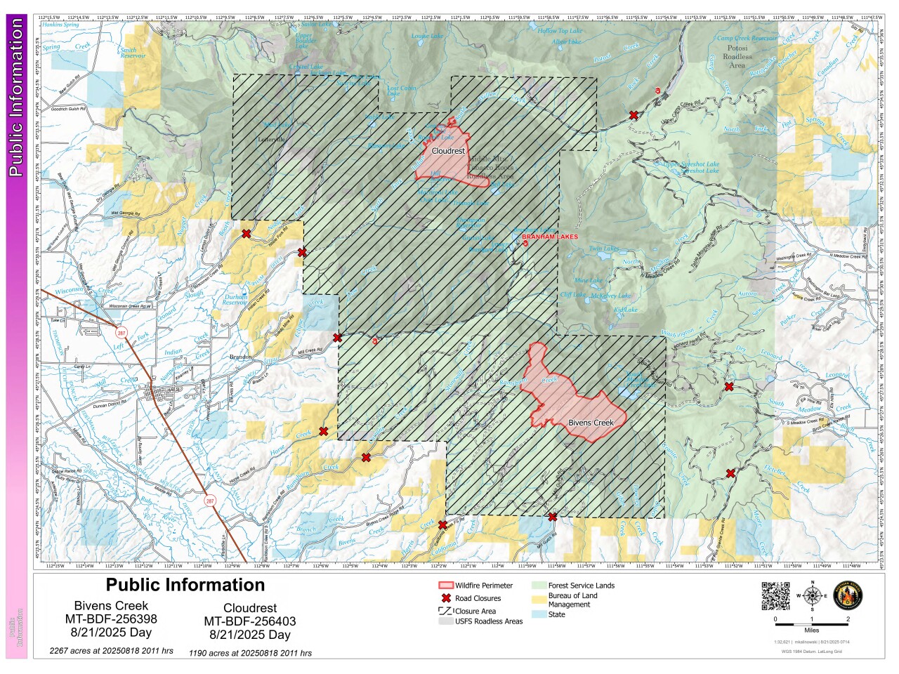
Forest closures and a Temporary Flight Restriction remain in place. Officials warn drones or unauthorized aircraft can halt firefighting flights.
Video: Two CL 215 scooper planes worked in tandem on the Bivens Creek and Cloudrest Fire on August 22, 2025. The filled from Rudy River Reservoir. The flight was a 10 minutes round trip. They carry approximately 1,400 gallons of water.
Photos: Smoke for a spot fire can be seen in Meadow Lake Basin looking southwest, on the Bivens Fire. Taken August 21, 2025.


UPDATE 10:32AM AUG. 22 — The Bivens Creek fire remains around 2266.9 acres with 0% containment. The Cloudrest fire has increased to 1732.8 acres with 0% containment.
At 10:12AM today Aug. 21, officials advised acreage estimates could not be updated overnight due to the inability to conduct an infrared mapping flight, but they believe both fires have continued to grow.
The Bivens Creek fire, first reported Aug. 13, has burned an estimated 2,267 acres and remains the top priority because of its proximity to homes in the South Meadow Creek area. Crews are working to strengthen fire lines, with helicopters dropping water and retardant on the east side. A spot fire was detected in the South Meadow Creek Lake basin, officials said. Over 270 personnel are assigned to the fire.
The Cloudrest fire, detected Aug. 14, is estimated at 1,190 acres. Crews pulled back from the Hill Reservoir area on the south end for safety reasons as the fire’s southwest corner intensified. Additional resources are needed for line construction on the north side near South Willow Creek. 62 personnel are working the fire, focusing on structure protection and scouting for safe containment opportunities.
Cooler temperatures and slightly higher humidity are expected today, but dry fuels and shifting winds — forecast to swing from the southwest to the northeast by early evening — could still drive active fire behavior.
Forest Service area closures remain in place and a Temporary Flight Restriction is active over the fire zone. Authorities remind the public that drones and private aircraft can halt air operations, putting firefighters at risk.
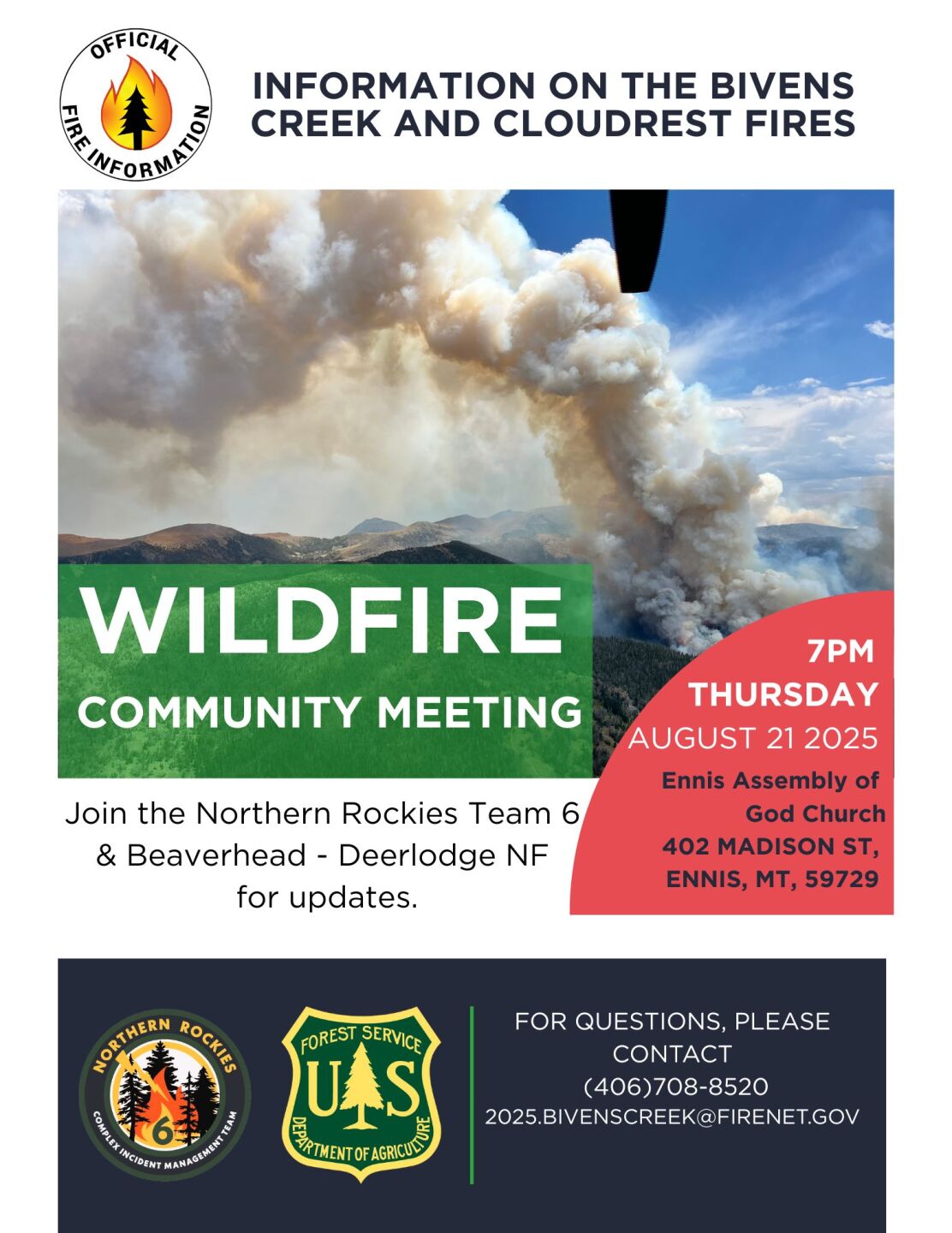
A community meeting will be held today at 7PM at the Ennis Assembly of God, located at 402 Madison Street in Ennis. Strategies, fire conditions, critical values and fire behaviour will be discussed.
For smoke and air quality updates, visit airnow.gov.