


BOZEMAN Mont: A very active and moist NW flow has been producing areas of heavy wet snow across SW Montana over the last 24 hours. Wet slushy roads made for difficult travel today.
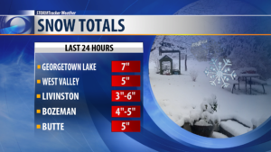
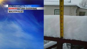
This trend is likely to continue into Wednesday but should diminish by Thursday morning. Look for additional snow accumulations and difficult travel into Wednesday morning.
A colder Canadian airmass is also dropping down into Montana and will keep temperatures, both at night and during the day, running colder than normal.
WINTER WEATHER ADVISORY:
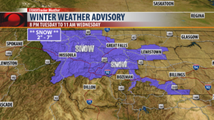
The National Weather Service has issued a WINTER WEATHER ADVISORY for areas west of the divide through 11 am Wednesday.
Another 2″ – 7″ of snow is possible with the heaviest snowfall over higher elevations and travel impacts are likely in the Georgetown Lake area, MacDonald Pass and Homestake Pass.
SNOWFALL MODELS:
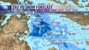
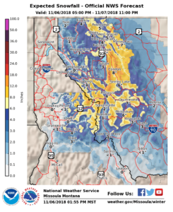
The STORMTracker Weather Forecast Snowfall model shows areas west of the divide have the best chance for additional moderate snowfall accumulations. Mountains could see 6″-12″ and lower valleys 2″-5″ of snow.
East of the divide look for scattered snow as well, however, snow accumulations should be on the lighter side with 1″ – 3″ of snow possible.
TRAVEL CONCERNS:
Great impacts to travel Tuesday night through Thursday morning will be the colder temperatures. Wet roads during the day will refreeze at night. Additional snowfall will also keep area roads wet and icy through Thursday morning.
Give yourself extra time to travel especially over all area mountain passes through the end of the week.
City by City Forecast:
BOZEMAN: LOW: 20°; HIGH WEDNESDAY: 33°. Colder! Scattered off and on snow is possible tonight into Wednesday with light accumulations for lower valleys like Bozeman but several inches are possible for mountain passes. Watch for icing to develop on area roadways tonight into Wednesday morning.
BUTTE: LOW: 18°; HIGH WEDNESDAY: 33°. Colder! More snow will hit areas west of the divide through Wednesday evening. Additional 2″ – 7″ of snow is possible. With the colder temperatures wet roadways will become very icy tonight into Wednesday morning.
DILLON: LOW: 21°; HIGH WEDNESDAY: 34°. Colder! Below normal highs and lows are likely for Dillon through the end of the week. Watch for a little more scattered snow showers through Wednesday evening mostly over area mountain ranges and mountain passes.
WEST YELLOWSTONE: LOW: 15°; HIGH WEDNESDAY: 30°. Colder! Scattered light snow is possible tonight into Wednesday. Wet roads will become icy.
