


BOZEMAN Mont: – A wintry weather pattern to grip Montana through most of this week. A moist NW flow aloft will continue to bring off and on or scattered snow showers to the state and accumulating snow is likely.
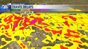
Mountains and passes will see moderate snowfall and difficult travel at times, whereas, most valleys will see light snow periodically leading to icy roads mostly during the morning commutes Tuesday and Wednesday.
A colder airmass will drop in starting Wednesday so prepare now for colder than normal temperatures through the end of the week and possibly into the weekend.
WINTER WEATHER ADVISORY
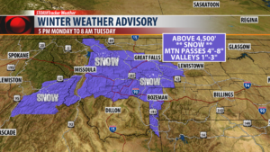
The National Weather Service has issued a WINTER WEATHER ADVISORY Monday at 5 pm through Tuesday at 8 am.
Snow is likely to produce wintry travel concerns with accumulating snow around 1″ – 3″ for lower valleys and 4″ – 8″ or most mountain passes.
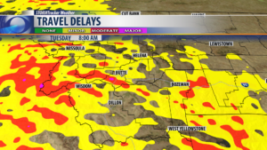
This will impact your Tuesday morning commute especially along I-90.
Travel concerns or delays are possible Tuesday morning see graphic below:
Travel concerns or delays are possible Wednesday morning see graphic below:
City by City Forecast:
BOZEMAN: LOW: 26°; HIGH TUESDAY: 36°. Scattered rain or snow Monday afternoon to give way to mostly scattered snow showers Monday night through Wednesday. Snow accumulations of 1″ – 3″ is possible and watch for icy roads.
BUTTE: LOW: 26°; HIGH TUESDAY: 36°. Scattered snow showers will develop Monday evening through Wednesday. Watch for possible icing on roadways especially during the early morning hours. Snow accumulations of around 1″-3″ is possible for Butte.
DILLON: LOW: 23°; HIGH TUESDAY: 38°. Scattered snow is possible for Dillon Monday through Wednesday. Snow accumulations should be generally under 2″ but enough snow is possible to create icy roads.
WEST YELLOWSTONE: LOW: 16°; HIGH TUESDAY: 33°. Scattered snow will develop for West Yellowstone Monday through Wednesday. Accumulating snow is likely 2″ – 4″ or more. Watch for snow covered and icy roads.
