

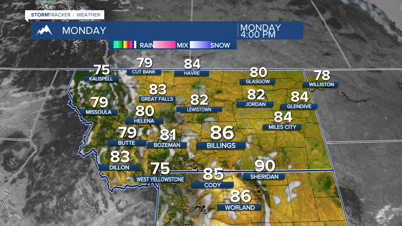


MONTANA — A very warm and dry start to the week will cover Montana, with Monday bringing near record temperatures and increased fire danger. The pattern stays mild through Friday before a potentially significant turn toward colder and wetter weather next weekend, including the possibility of mountain and lower-elevation snow.
MONDAY
Highs across much of central and eastern Montana will reach the 80s, with temperatures around 20 degrees above normal in parts of north-central Montana. Missoula, Butte and Kalispell will also be unusually warm, while Billings, Sheridan and Livingston could approach or reach record highs.
Dry conditions and increasing winds will raise fire-weather concerns. Gusts over 30 to 35 mph are possible near the Rocky Mountain Front and central Montana mountains. South-central Montana will also become breezy, and a Red Flag Warning is in effect along portions of the western foothills from 10 a.m. through 8 p.m.
TUESDAY
A weak, dry cold front crosses south-central and southeast Montana, turning winds more northerly and lowering temperatures into the 70s. Farther west, the ridge begins flattening, but the main noticeable change will be somewhat stronger mountain breezes. Northeast Montana also remains under the influence of the warm, dry ridge.
WEDNESDAY
Warm and dry October weather continues across Montana. The ridge rebuilds somewhat over south-central and southeast Montana, supporting sunshine and highs generally in the 70s to near 80. Western Montana remains mild and largely dry under west-to-east flow.
THURSDAY
Little overall change is expected. Temperatures remain well above early-October averages across much of Montana, with dry weather continuing. Afternoon mixing could again produce periods of breezy weather, especially across central and eastern portions of the state.
FRIDAY
Friday looks like the final day of the extended warm spell. Temperatures across north-central and southwest Montana are expected to remain roughly 10 to 15 degrees above average, while south-central and southeast Montana could climb back into the lower 80s. Increasing winds and continued dry conditions may again elevate fire-weather concerns across eastern and south-central Montana.
SATURDAY
A major weather change begins to take shape. A cold front is expected to move through western Montana late Friday into early Saturday, with colder air spreading across the state during Saturday. North-central and southwest Montana could turn 10 to 20 degrees colder than Friday. Northeast Montana is also expected to cool Saturday.
Precipitation chances should increase behind the front, although the timing and amounts remain uncertain.
SUNDAY
A much colder and wetter pattern could become established across Montana. Great Falls forecasters indicate increasing confidence in widespread snowfall potential Saturday night into the beginning of the following week, with western and central Montana favored for accumulating snow. Billings forecasters also indicate the colder pattern could produce accumulating mountain snow across their region.
Western Montana could see significant mountain snow potential develop into early next week, particularly near the Continental Divide. Afternoon temperatures there may eventually fall 20 degrees or more below the warm readings expected Thursday or Friday. There is still substantial uncertainty in the precise storm track, precipitation amounts and snow accumulations, so this portion of the forecast bears watching.
