

BOZEMAN – A very complex atmosphere over Montana is developing today. The combination of arctic air digging in from the North and pacific moisture moving in from the west will combine to produce more scattered snow, gusty winds, areas of blowing snow, below zero wind chills, frost bite within 30 minutes and poor to hazardous travel.
Forecast models continue to show the deep arctic air with the coldest temperatures to stall over central and northern Montana. This region will likely see below zero highs and lows and possible wind chill values colder than -40 below at times and possibly colder than -50 below along the hi-line.
Greatest travel impacts will continue to be along the MT/ID state line Sunday evening through Wednesday. Mountain passes will see moderate to heavy snow at times, gusty winds, blowing snow, and dangerous travel conditions. Mountain passes with the most severe impacts will be: Lookout Pass on I-90, Monida Pass on I-15, Island Park, ID, Lolo and Lost Trail Passes, and passes along the Rocky Mountain front.
WINTER WEATHER HIGHLIGHTS
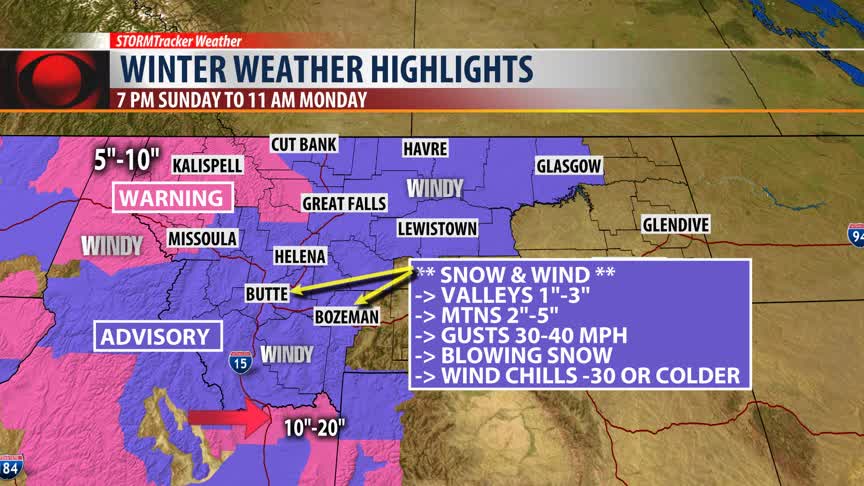
The National Weather Service has a Winter Weather Advisory up for all counties in SW Montana from 7 pm Sunday to 11 am Monday.
Valleys could see an inch or two of snow, but mountain passes will likely pickup 2”-5” of snow by Monday morning. This will impact those who travel over Bozeman pass and Homestake pass. Watch for snow and blowing snow with reduced visibility and wind chills below zero.
Another round of snow is likely Monday evening into Tuesday morning with similar travel hazards for your Tuesday morning commute as described above.
The National Weather Service has a WINTER STORM WARNING up for Eastern Idaho. This includes Monida pass over to Island Park, ID. Another foot of snow is possible through Tuesday. Areas of blowing and drifting snow and this could produce hazardous to dangerous travel conditions.
The National Weather Service has a WINTER STORM WARNING up in NW Montana tonight into Monday. This includes I-90 from Missoula to Lookout Pass into the Idaho panhandle. A foot of additional snow is possible tonight into Monday over Lookout Pass.
Areas of heavy snow and strong winds are also likely to develop along the Rocky Mountain front near Glacier National Park.
ARCTIC BLAST UPDATE
Forecast temperatures over the next 3 to 5 days will be bitterly cold for most of central, northern, and eastern counties of Montana. This region will see below zero highs and lows for the first half of the new work week.
Western and SW Montana counties should expect a drop-in temperature as well, but not nearly as cold as northern Montana.
The greatest concern for SW Montana counties will be bitter wind chill values during the morning hours Monday through Wednesday. Feels like temperatures at times, even with a light 5 to 10 mph wind, will fall well below zero between -5 to -15 below zero.
FORECAST LOWS THROUGH THURSDAY
Latest forecast temperatures. Please check back for updated numbers at 5:30 pm and 10 pm tonight on KXLF and KBZK.
