

BOZEMAN – The next weather maker will race across Montana Wednesday. A powerful Pacific cold front will pass over Montana producing strong to possibly damaging wind gusts and mountain snow.
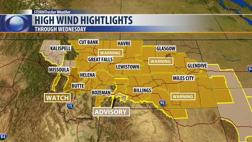
The greatest concern in the short term forecast for Wednesday is wind. Almost the entire state of Montana is under a high wind highlight. There are High Wind Warnings for most of Montana and a few areas under a Wind Advisory. Here is the breakdown:
The National Weather Service issued a HIGH WIND WARNING for Jefferson, Lewis & Clark, Broadwater, Meagher and Gallatin counties of SW Montana Wednesday 6 am through 7 pm.
Sustained winds 25 to 35 mph are likely with peak wind gusts at times between 60 to 70 mph.
Traveling Wednesday will be very difficult to hazardous especially for high profile vehicles.
Wind Advisory is up for the Livingston area tonight through Wednesday night. Peak wind gusts up to or over 60 mph are likely. If the crosswinds become too dangerous I-90 may be closed in the Livingston area so plan on possible travel delays.
The National Weather Service issued a HIGH WIND WATCH for the Butte/Blackfoot region tonight through Wednesday evening.
Conditions look favorable for strong WSW winds 30 to 40 mph sustained and possible peak gusts up to or over 60 mph.
One area of concern will I-90 between Fairmount Hot Springs to Deer Lodge. This stretch of I-90 is a crosswind hazard. Georgetown Lake, MacDonald Pass, Butte, Anaconda and Deer Lodge could experience property damage if gusts exceed 60 mph.
