


AIR QUALITY CONCERNS:
Upper level trough is forcing wildfire smoke mostly from Canada to drop down into Montana Sunday and Monday.
Air Quality Alerts continue for much of the western half of Montana through Wednesday morning and all of the pacific NW.
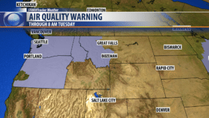
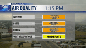
Local air quality has improved slightly throughout the day Monday with the approaching storm system. Early morning ratings were mostly in the “Unhealthy” range but has improved to “Unhealthy for sensitive groups” by Monday afternoon.
NEXT WEATHER MAKER:
A slow moving upper level Low is moving into SW Montana Monday afternoon. This will lock our weather pattern into a cool, windy and wet one for another 24 hours. Temperatures are well below normal today and we will be lucky to see the lower 60s Monday afternoon. Gusty winds have been developing all day and will likely continue into tonight with occasional gusts over 30 mph. This Low should produce widespread showers and thunderstorms Monday afternoon through Tuesday morning. Locally heavy rain is possible but frequent lightning and stronger wind gusts are also possible with a couple of storms reaching severe potential this afternoon.
City by City Forecast:
BOZEMAN: LOW: 48°; HIGH TUESDAY: 71°. Showers and thunderstorms possible this evening along with gusty winds. Additional showers and rumbles are possible Tuesday morning but should be ending Tuesday evening.
BUTTE: LOW: 45°; HIGH TUESDAY: 67°. Chilly pattern for another 24 hours for Butte. Showers and thunderstorms will be increasing Monday afternoon and evening. Gusty winds will continue into Tuesday. Most of the wet weather will be ending by Tuesday late afternoon.
DILLON: LOW: 43°; HIGH TUESDAY: 73°. Temperatures will remain cooler than normal through Tuesday for Dillon. Showers and thunderstorms are likely Monday afternoon through Tuesday morning and ending late Tuesday afternoon. Strong wind gusts are likely over 30 mph.
WEST YELLOWSTONE: LOW: 36°; HIGH TUESDAY: 71°. Showers and thunderstorms will be building over West Yellowstone Monday afternoon through Tuesday afternoon. Locally heavy rain is possible. Watch for stronger thunderstorms through midnight Monday. Frequent lightning and gusty winds are possible. Temperatures will remain very chilly through Wednesday morning.
