


BOZEMAN – A strong cold front passed through SW Montana Monday late morning through early afternoon producing brief and intense snow and wind which prompted Snow Squall Warnings to be issued by the National Weather Service.
Especially hit hard with near zero visibility with snow and wind hit the Belgrade, Bozeman and Bozeman pass areas around 1 pm Monday.
This frontal system will move off into eastern Montana by this evening and will likely create hazardous travel conditions along I-90 and I-94 with snow and windy and icy road conditions.
A Winter Weather Advisory remains in place for Bozeman Pass through 11 pm Monday. Expect winter travel conditions and slow-go travel with slushy covered, wet, and possibly icing of road surfaces for your Monday evening commute.
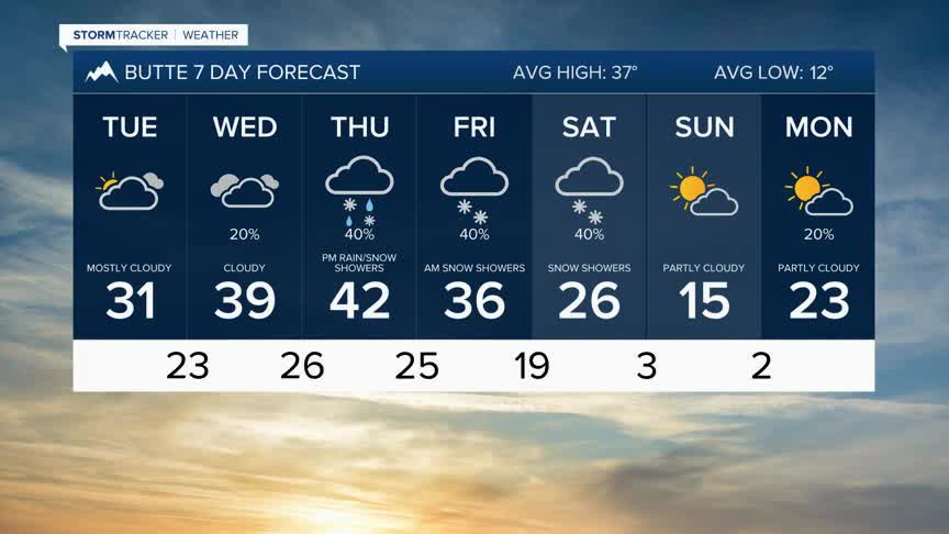
Tuesday should be a little quieter weather-wise with a slight chance for a few mainly mountain snow showers.
A quick shot of snow is possible with a weak disturbance Wednesday morning, and light valley snow is possible with a better chance for accumulating snow over mountain passes. This system should exit the region by Wednesday afternoon.
Yet another Pacific storm will move in from the West Thursday afternoon and initially produce valley rain or snow and mountain snow, but Arctic air digs in behind this storm Thursday evening, and widespread snow and much colder temperatures arrive by Friday morning.
Snow and cold will linger over most of Montana Friday through Saturday and significant travel impacts are expected. Below zero wind chills will be the main weather hazard by Saturday.
