


BOZEMAN – A strong Pacific storm will create a blast of winterlike weather across the entire region Wednesday evening through Friday morning.
The forecast has wind, snow, and cold for all of Montana with accumulating snow at all levels. This means wintry travel conditions are coming to impact your Thursday morning, Thursday evening, and Friday morning commutes.
The National Weather Service issued a Winter Weather Advisory for the Butte/Blackfoot and Upper Big Hole Region from 6 pm Wednesday through 9 am Thursday. Valley snow accumulations 1”-4” with 3”-7” possible for mountains and passes. Wind gusts 30 to 40 mph are also possible with this cold front tonight.
The National Weather Service has issued a WINTER STORM WATCH (soon to be upgraded so please check back in at 5:30 pm and 10 pm tonight) for the Madison and Gallatin Ranges including the Gallatin Valley. 5”-10” of valley snow is possible around Bozeman with 10”-15” for mountains and passes. Wind gusts up to 45 mph are possibl ewith this cold front. The Watch runs from Wednesday evening through Thursday evening but again this will get upgraded soon.
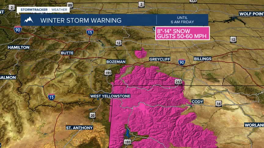
The National Weather Service has issued a WINTER STORM WARNING for the Crazy mountains, Absaroka-Beartooth Range and all of Yellowstone National Park now through 6 am Friday. Total snow accumulations8”-14”is possible with higher amounts for the taller peaks. Wind gusts 50-60 mph is likely with the cold front.
The National Weather Service has a HIGH WIND WARNING up through 9 pm Wednesday for the Lima to Dillon to Twin Bridges region and the Madison River valley floor including Ennis. Peak wind gusts up to 60 mph are possible.
