


Today's Forecast: Fog is likely for the start of your Monday with highs topping out in the upper 50s and low 60s and a light northerly wind between 5-15 mph.Expect a few spotty showers throughout the day with the heaviest rain expected well to our north.Skies will begin to clear tonight leaving lows in the middle and upper 30s.
BOZEMAN: High: 61; Low: 37. Pockets of fog are likely for the morning. Our skies will remain mostly cloudy with spotty light showers possible through the early evening.Winds will stay out of the northwest between 5-15 mph.
BUTTE: High: 57; Low: 35. Light showers are likely for the morning with a few spotty showers for the afternoon.Amounts will be limited but showers are not expected to be heavy.Skies will clear this evening and leave lows in the middle 30s.
DILLON: High: 65; Low: 39. Mostly cloudy skies with a spotty light shower possible.Winds will stay out of the northwest between 5-15 mph.
WEST YELLOWSTONE: High: 60; Low: 29. A few light showers are possible today, but our chances are limited. Expect partly cloudy skies with highs near 60°.
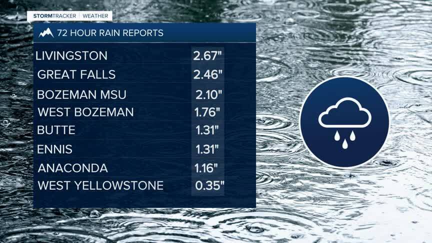
IMPRESSIVE RAIN TOTALS: Rain totals since Friday have been impressive with Livingston picking up the highest totals in southwest Montana totaling 2.67”. While this rain helps, it won’t erase drought conditions overall even though the year-to-date numbers for Bozeman and Butte put us near where we should be for this point in the year.We need several more stretches of rain like this to back us out of drought conditions in western Montana.
As for this week, there are several rain chances that come into play after Monday.By Thursday we will have another front move in bringing showers.We could see another cool-down with showers move in on Sunday.
