


BOZEMAN – One of the craziest weather patterns I can recall for mid-December across Montana over the next couple of days.
Moderate to heavy rainfall Tuesday and Wednesday is producing flooding issues in far NW Montana in Lincoln County. There are flood highlights (Watches, Warnings, and Advisories) up into Thursday evening and possibly extended into Friday. The good news for NW Montana is the line of moderate to heavy precipitation is sinking southward.
Arctic air is slowly digging into northern and central Montana Thursday afternoon. At the time of this report, Cut Bank is 5 degrees vs 59 degrees in Billings.
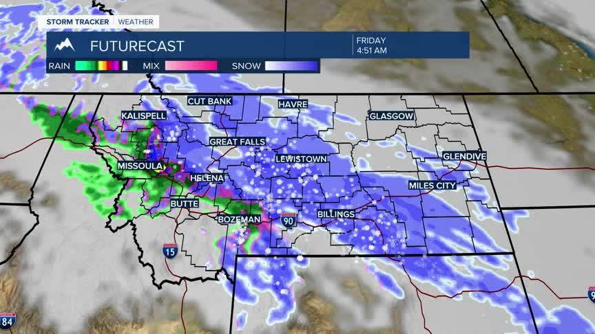
As the warm and very moist subtropical moisture overruns the colder surface Arctic air this creates greater lift and thus a high probability of widespread heavy snow. In fact, there could be some mixed precipitation with pockets of freezing rain through Thursday evening but as the colder air digs in this should be a significant snow event for most of Montana east of the divide.
The only exception is SW Montana. The brunt of this winter storm is expected to bypass SW Montana. Rain is expected for lower valleys as SW Montana should remain in the warm sector of this weather pattern. That could change but for now valley rain and mountain is in our forecast through Saturday morning.
The National Weather Service has WINTER STORM WARNINGS up for most of northern, central, eastern and SE Montana counties from Thursday evening through Saturday morning.
Very heavy wet snow is expected with general valley snow accumulations between 6”-12” with a few areas possibly reaching the 20”+ mark. Wind gusts up to 40 mph could produce localized areas of blowing. Area of greatest concern will stretch from Cut Bank to Billings.
If this storm develops as expected, road crews will have a difficult time keeping roads open Thursday night through Friday night.
