


Today's Forecast:
Southwest Montana will see another hot, dry and smoky day with widespread sunshine filtered through wildfire haze. Air quality concerns remain elevated across the region, especially during the morning and overnight hours as smoke settles into the valleys. Afternoon southwest to west winds will increase between 10 and 20 mph, creating breezy conditions and maintaining elevated fire danger through the day. Later this week we should see at least slightly better air quality as a front drives through the area.

BOZEMAN: High: 88; Low: 54. Mostly sunny with smoky and hazy conditions continuing throughout the day. Southwest to west winds increase this afternoon to 10 to 20 mph with occasional gusts above 25 mph. Air quality may become unhealthy for sensitive groups at times. Warm and dry weather continues tonight with lingering smoke.
BUTTE: High: 86; Low: 47. Sunny skies mixed with persistent smoke and haze through the day. West winds strengthen this afternoon to 10 to 20 mph, producing breezy conditions through the evening hours. Reduced visibility and poor air quality remain possible, especially this morning and again overnight.
DILLON: High: 88; Low: 52. Hot, dry and smoky with mostly sunny skies. West-southwest winds increase to 10 to 20 mph this afternoon with occasional gusts approaching 30 mph in open areas. Air quality concerns continue through the day as wildfire smoke lingers across the valleys and grasslands.
WEST YELLOWSTONE: High: 84; Low: 46. Mostly sunny with hazy skies from ongoing wildfire smoke. Southwest winds increase this afternoon to 10 to 20 mph with gusts near 25 mph possible. Dry weather continues tonight with cool overnight temperatures and smoky conditions lingering into the evening.
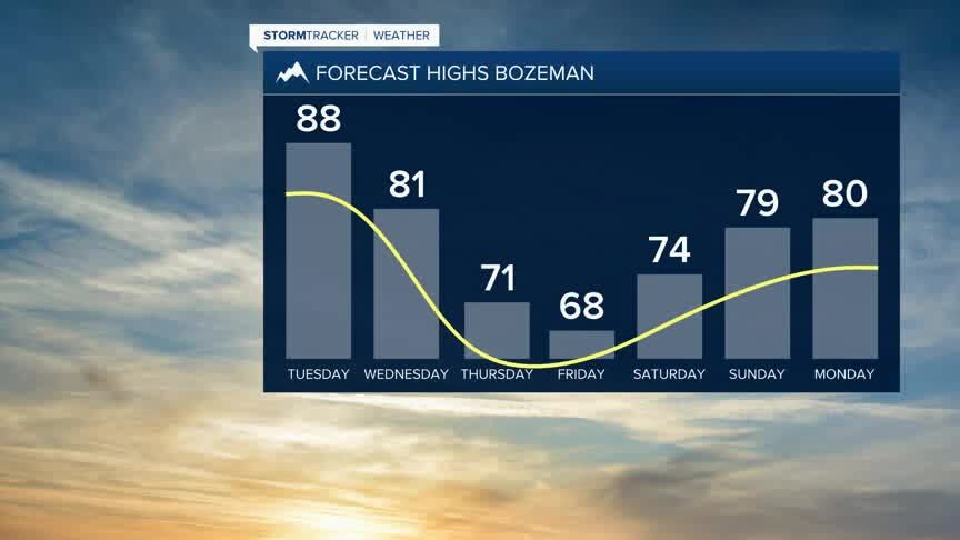
COOLER TEMPERATURES LATE THIS WEEK
Hot, dry and breezy weather will continue through midweek, keeping elevated fire danger concerns in place across southwest Montana. A pattern change is expected late this week as cooler air and increasing moisture move into the region, bringing better chances for showers and thunderstorms by Thursday into Friday. Smoke and air quality issues may gradually improve late in the week if wetter conditions become more widespread.

Wednesday should bring some isolated thunderstorms to the area during the late afternoon as monsoonal moisture works back into the area. A cold front driving into the should knock those temperatures down and clear our skies but also bring us better rain chances to the area Thursday through Saturday.
