


Today's Forecast:
Southwest Montana will see a much cooler and more unsettled weather pattern today with widespread clouds, scattered showers and periods of thunderstorms developing through the afternoon and evening. Areas of wildfire smoke may still linger at times, but improving moisture and cooler temperatures should gradually help air quality conditions. Breezy winds will develop this afternoon, especially near thunderstorms where gusty and erratic winds are possible.

BOZEMAN: High: 69; Low: 51. Mostly cloudy with patchy smoke early this morning. Showers and thunderstorms become more widespread this afternoon and evening, with locally moderate rainfall possible at times. East southeast winds around 5 to 10 mph increase slightly later today. Wet conditions continue tonight with scattered showers lingering overnight.
BUTTE: High: 69; Low: 47. Mostly cloudy skies with scattered showers developing through the day. Thunderstorms become possible this afternoon and evening with brief heavy rain and gusty winds possible near stronger storms. North to northwest winds increase between 10 and 15 mph this afternoon. Cooler temperatures continue tonight with lingering showers possible.
DILLON: High: 72; Low: 50. Mostly cloudy with isolated showers early, followed by increasing chances for showers and thunderstorms this afternoon and evening. Southwest winds increase to 10 to 15 mph during the afternoon hours. Cooler temperatures and higher humidity continue tonight with scattered showers lingering overnight.
WEST YELLOWSTONE: High: 70; Low: 41. Cloudy skies with scattered showers developing through the day and thunderstorms possible during the afternoon and evening hours. Southwest winds increase between 10 and 20 mph with occasional higher gusts possible near storms. Cooler conditions continue tonight with showers lingering into the overnight period.
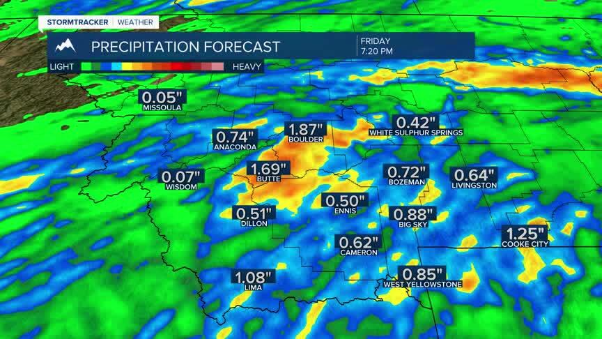
COOL AND WET PATTERN ARRIVES
A much cooler and wetter weather pattern settles across southwest Montana through the remainder of the week. Periods of showers and thunderstorms are expected daily through at least Friday, with locally heavy rainfall and gusty winds possible at times. Fire danger and smoke concerns will gradually improve as humidity levels rise and temperatures trend below seasonal averages heading into the weekend.

FLOODING CONCERNS WITH RAIN
While widespread flooding is not expected at this time, periods of moderate to heavy rainfall could lead to localized ponding of water, minor urban flooding and rapid rises on small creeks and streams through late week. Areas near recent burn scars and steep terrain will be more vulnerable to brief runoff issues during heavier thunderstorms. Residents should continue monitoring forecast updates as rainfall totals become more certain over the next several days.
