
BOZEMAN – A few key weather pattern elements to track in your weekend forecast. Overall, most of SW Montana should be warm and dry, however, monsoonal moisture will lift up into the region producing showers and isolated thunderstorms Saturday south of I-90 and another dry cold front will move in late Saturday increasing surface winds along with higher fire danger.
The above on-demand STORMTracker video forecast with Chief Meteorologist Mike Heard will walk you through the forecast hour-by-hour and show you the timing, location, and intensity of possible showers and thunderstorms. The Fire Weather Watch mentioned in the above video was upgraded to a Fire Weather Warning while updating this web story so the information below is most current.
FIRE WEATHER WARNING (RED FLAG WARNING)
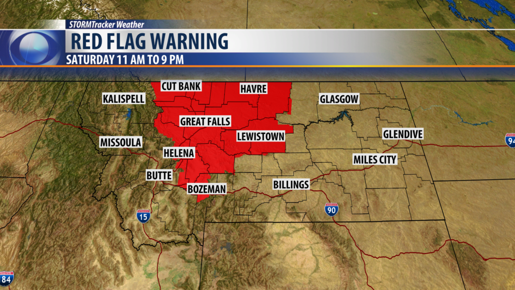
The National Weather Service issued a Fire Weather Warning for central and northern counties of Montana and locally for Broadwater, eastern Jefferson and northern Gallatin counties Saturday from 11 am to 9 pm. This region will see the stronger surface winds, low relative humidity, and hot temperatures along with a few dry thunderstorms. All-weather factors will lead to a higher risk of new fire starts.
Although most of SW Montana is not under any fire weather highlights this weekend we will see gusty winds with a cold front Saturday afternoon and evening. Please use extreme caution with your outdoor activities to avoid an accidental fire start.
City by City Forecast:
BOZEMAN: LOW: 58°; HIGH SATURDAY: 84°. Mostly cloudy this evening and into Saturday. A few showers are possible south of Bozeman in the morning Saturday but a few late-day thunderstorms could hit Bozeman Saturday. Surface winds will be increasing by afternoon and evening 10 to 20 mph.
BUTTE: LOW: 56°; HIGH SATURDAY: 85°. Partly cloudy to cloudy Friday afternoon. Mostly cloudy Friday evening with a few isolated showers or rumbles of thunder. Saturday should be mostly cloudy a few showers or isolated thunderstorms and increasing surface winds by afternoon 10 to 20 with gusts over 30 mph.
DILLON: LOW: 56°; HIGH SATURDAY: 85°. Clouds are rolling in over Dillon Friday afternoon. Mostly cloudy skies will continue into Saturday with a few showers in the morning and a few isolated late-day thunderstorms. West winds will be increasing by afternoon 10 to 20 mph gusts over 30 mph are possible.
WEST YELLOWSTONE: LOW: 44°; HIGH SATURDAY: 80°. Mostly cloudy with a few showers or thunderstorms overnight. Saturday look for morning showers or thunderstorms and scattered afternoon thunderstorms are possible. Surface winds will be increasing 10 to 20 mph.
