

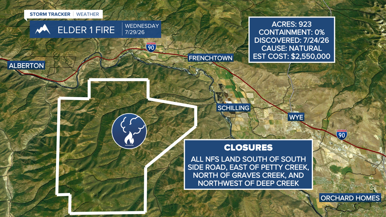


FRENCHTOWN — UPDATE: 7-30-2026, 10:50 a.m. — Hundreds of fire personnel continue to battle the Elder 1 fire.
In an update Thursday morning, the Lolo National Forest said the fire remains at 923 acres. Forest officials said area and road closures are in effect starting Thursday around the fire. You can find detailed closure information here.
Officials said aviation and ground crews will work together to burn out the unburned vegetation below Albert Point.
"Preparations for this strategic firing operation include continuing and tying in dozer line construction toward Albert Point, establishing retardant line, and positioning ground crews to hold and secure control lines," the Lolo National Forest wrote in a Facebook post.
In the post, they said crews will assess structures in neighboring areas and develop contingency plans in case of a weather shift.
Overnight, forest officials said the fire broke a control line on the northeastern edge and crews conducted a small burnout operation to contain the "slop-over."
UPDATE: 7-29-2026, 6:45 p.m. — The Northern Rockies Complex Incident Management Team 1 said the Elder One Fire has grown to 923 acres with 0% containment in its Wednesday evening update.
Watch the full update below:
UPDATE: 7-28-2026, 2:45 p.m. — The U.S. Forest Service has closed a number of roads and trails due to the Elder One Fire.

DESCRIBED AREAS
All National Forest System lands south of the Clark Fork River in: T13N R21W Sec. 6; T13N R22W Sec. 1-5, 8-17, 21-24; T14N R21W Sec. 4, 10, 14, 16-21, 26, 28-32; and T14N R22W Sec. 9-17, 20-29, 32-26
DESCRIBED ROADS
All National Forest System Roads within the Described Areas.
DESCRIBED TRAILS
All National Forest System trails in the Described Area, including NFST 8, 718, 719, 720, 731, 732, and 733. Portions of these trails not within the Described Area are not included.
PREVIOUS:
The Northern Rockies Complex Incident Management Team took command of the Elder One Fire in Montana Tuesday morning, bringing more resources to fight the flames and freeing up local crews to respond to any new fires.
The new command team thanked the local Lolo National Forest crews for their hard work so far.
Lightning started the fire July 24. It is burning about 7 miles southwest of Frenchtown in the Rock Creek area and has grown to an estimated 510 acres and is currently 0% contained.
Four crews and 6 engines are currently assigned to the fire. Three dozers, five water tenders, and helicopters are also on scene.
Flames moved uphill toward Albert Point Monday. Firefighters made progress building control lines along the east side of the fire, and airplanes dropped fire retardant along a western ridge. Hotshot crews are now building direct lines on the north and south sides with help from helicopters and heavy equipment.
Weather conditions are making the fight more difficult Tuesday. The area is hot and dry, wind gusts could reach 20 miles per hour in the afternoon, and smoke from other regional wildfires is lowering visibility.
Tuesday, crews plan to hold the ridge from Rock Creek to Albert Point and keep the fire north of Rock Creek. Crews are also looking for more places to build control lines away from local powerlines. More firefighters and equipment are arriving daily to help contain the blaze.
Officials are discussing a temporary closure for the entire fire area. For now, they want the public to stay away from the immediate area. Drivers should avoid Deep Creek Road.
A temporary flight restriction is in place over the fire. Officials warn that flying drones in the area is dangerous, as drones can cause accidents and force firefighting aircraft to stay on the ground.
"Firefighting aircraft and drones are a dangerous combination. Drones in the area could lead to accidents or slow down wildfire suppression operations. If you fly…we can’t."
This story was reported on-air by a journalist and has been converted to this platform with the assistance of AI. Our editorial team verifies all reporting on all platforms for fairness and accuracy.
