Thick wildfire smoke continues to move over SW Montana today and it’s very noticeable Wednesday afternoon.
Most of the smoke is coming from wildfires in the Pacific NW and northern California. As long as a SW flow aloft is in place wildfire smoke will continue to roll over Montana. This trend is likely to continue into Thursday but by the weekend a NW flow should help improve air quality locally.
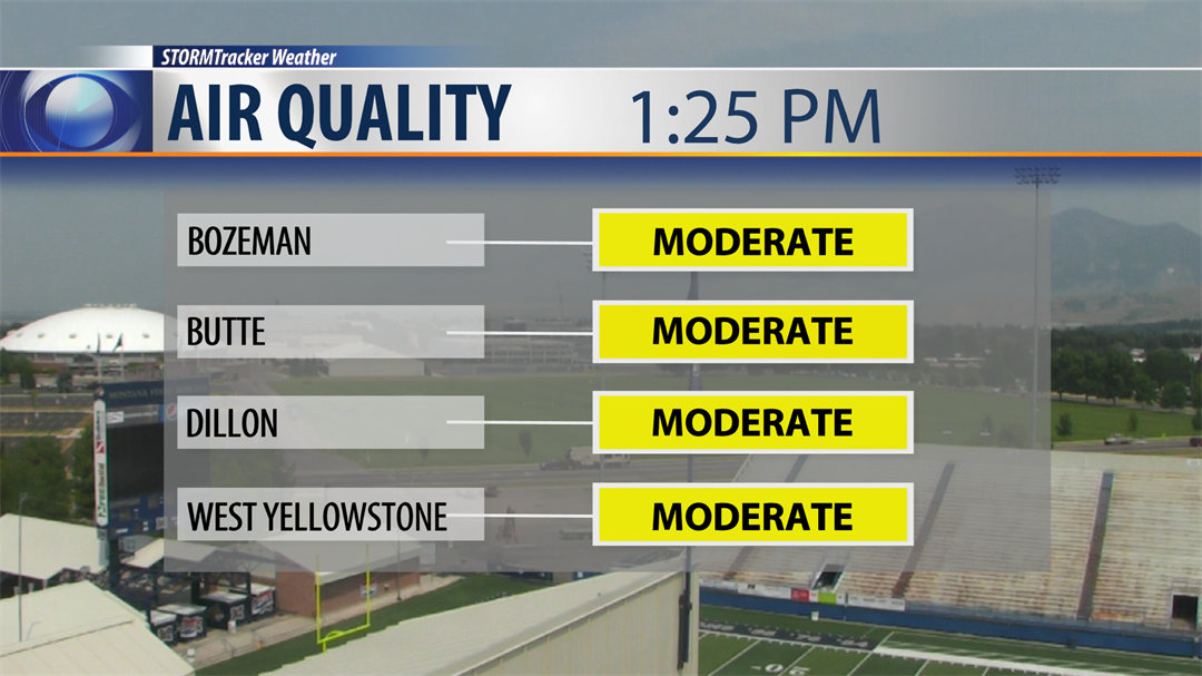
As of 1 pm air quality reporting stations in SW Montana is holding in the "Moderate" particulate range. Those that are sensitive to the wildfire smoke should limit your exposure as much as possible through Friday.
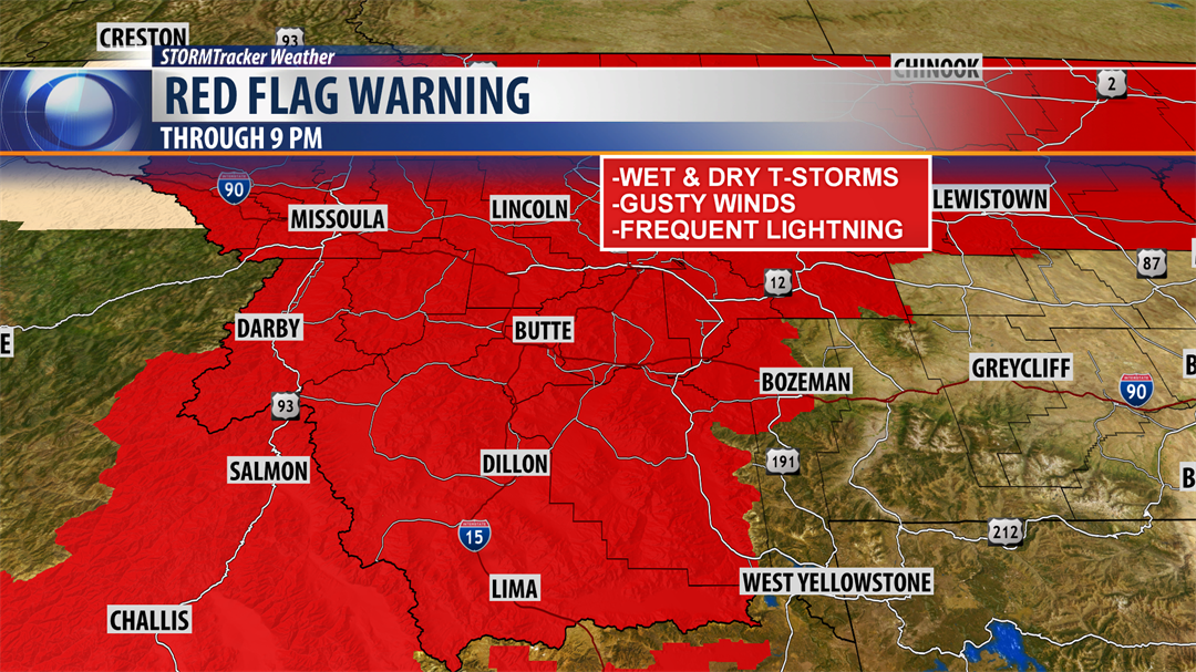
The other concern in today’s weather trends is the potential for new wildfire starts as pop up thunderstorms hit SW Montana.
The National Weather Service has issued a RED FLAG WARNING through 9 pm this evening. A RED FLAG WARNING is also up for Thursday afternoon and evening for SW Montana.
What does this mean? There will likely be a mix of dry and wet thunderstorms Wednesday afternoon and again Thursday afternoon. Frequent lightning and gusty winds could lead to new fire starts in our region. If you see a lightning caused fire please report it as soon as possible to law enforcement.
The on demand STORMTracker video forecast (above) from Chief Meteorologist Mike Heard will walk you through the timing, location and intensity of possible thunderstorms Wednesday into Thursday. Please check back in with Mike tonight at 5:30 pm and 10 pm for additional updates on KBZK.
City by City Forecast:
BOZEMAN: LOW: 56°; HIGH THURSDAY: 87°. A slight chance for a late afternoon to early evening thunderstorm for Bozeman. Most thunderstorms should develop south of Bozeman. Very smoky again today and that trend will continue overnight into Thursday.
BUTTE: LOW: 51°; HIGH THURSDAY: 87°. Butte could see a pop up thunderstorm this afternoon into this evening. Most storms will quickly diminish around sunset. Wildfire smoke will also stick around for a few more days.
DILLON: LOW: 52°; HIGH THURSDAY: 88°. A weak disturbance will trigger scattered thunderstorms over Beaverhead County this afternoon including Dillon. Frequent lightning, gusty winds could lead to new fire starts. As long as this SW flow aloft is in place more wildfire smoke will continue to roll over Dillon at least through Thursday.
WEST YELLOWSTONE: LOW: 41°; HIGH THURSDAY: 80°. Scattered thunderstorms are likely this afternoon and evening for West Yellowstone but should drop off after sunset. Thursday afternoon look for a few pop up thunderstorms as well. Wildfire smoke will also stick around for several more days.
NEXT WEATHER MAKER:
Heading into the weekend the pattern will be changing as High pressure weakens and an upper level trough digs into the Pacific NW cooling the region down beginning Friday. This pattern change should help improve air quality across Montana this weekend but until then look for more wildfire smoke to pass over the state and air quality issues to continue Thursday into Friday.
