


Today's Forecast: Milder temperatures for your Monday with a mix of clouds. Highs will stay in the upper 50s and low 60s for most of the region with a light northwest wind between 5-10 mph. Isolated mountain snow showers are possible in the Gallatin and Madison ranges. A few spotty showers are possible for your Tuesday.
BOZEMAN: High: 61; Low: 37. Mild with a mix of clouds. Winds will be light out of the northwest.
BUTTE: High: 57; Low: 33. Clouds increasing across the region with a light northwest wind between 5-10 mph.
DILLON: High: 59; Low: 37. Partly cloudy skies with mostly cloudy skies for the evening.
WEST YELLOWSTONE: High: 51; Low: 28. Mild with a light wind. Look for increasing clouds and a slight chance of a few flurries tonight. Little to no accumulation is expected.
CURRENT SNOWPACK AND THE WEEK AHEAD:
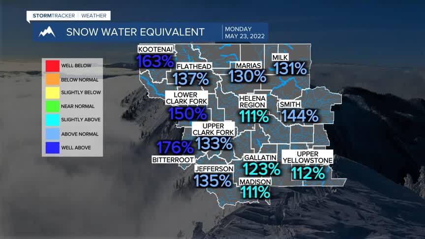
Montana’s snowpack is encouraging right now. All basins are above average as it stands right now. The latest mountain snow has pushed numbers significantly. While this is encouraging it is important that we stay mindful of how quickly the snow begins to melt and how our runoff season begins to pick up.
This week will once again bring warmer temperatures with highs expected to top out in the middle 70s by Thursday. Your Memorial Day weekend will likely be cooler with scattered showers through Monday. Highs are expected to be in the low 50s Saturday through Monday with rain for the valleys and a mix of rain and snow for the mountains in the region.
