BOZEMAN – 3 pm Thursday update on approaching severe winter weather to impact Montana.
The forecast has changed only slightly from my previous post. The National Weather Service has updated winter storm watches into winter storm warnings.
First come areas of heavy wet snow beginning Thursday night with a better chance for heavy wet valley snow throughout the day on Friday. Snow will continue Friday night into Saturday morning and slowly diminish by Saturday evening.
Heavy wet snow is likely with a high-water content that will melt as it hits the pavement tonight into Friday and accumulate at high elevations. Slush covered roads could “flash freeze” Friday night into Saturday morning as Arctic air digs in produce extremely icy road conditions and rough chunky ice on the roadways.
Other travel hazards will be periods of heavy snow, low visibility with some localized blowing snow and wet slushy roads turning to ice.
The National Weather Service issued a WINTER WEATHER ADVISORY west of the divide from 5 pm Thursday through 1 pm Friday. Note: this advisory turns into a winter storm warning beginning at 1 pm Friday.
Light to moderate snow will impact travel at all levels tonight into Friday morning.

The National Weather Service issued a WINTER STORM WARNING west of the divide beginning 1 pm Friday through 1 pm Saturday and includes the Butte-Anaconda-Georgetown Lake-Deer Lodge areas as well as Missoula to Kalispell region.
Snow accumulations around 6”-12” or more is possible at all levels. Watch for wind gusts to 40 mph producing areas of blowing snow and low visibility. Wet roads will become extremely icy Friday night into Saturday morning.
The National Weather Service issued a WINTER STORM WARNING east of the divide for most mountain ranges and for several lower valleys. The warning begins at 5 pm Thursday to midnight Saturday for most mountain ranges. The warning begins at lower elevations starting at 11 am Friday to midnight Saturday.
Mountain snow 1’ to 3’ is possible, this includes Big Sky and West Yellowstone and inside Yellowstone National Park. Lower valleys could see 6”-12” or more including Bozeman, Ennis, White Sulphur Springs, Livingston to Billings.
Wind gusts of 30 to 40 mph could produce areas of blowing snow and low visibility travel hazards. Also watch for wet roads to flash freeze Friday night into Saturday morning.

The National Weather Service issued a WINTER WEATHER ADVISORY for lower elevations from Helena to Townsend through Three Forks over to Whitehall and down through Twin Bridges to Dillon to Monida Pass from 11 am Friday to midnight Saturday.
Look for 3”-8” or more of total snow. Watch for flash freezing of wet roads Friday night into Saturday morning and watch for gusty surface wind producing areas of blowing snow and low visibility.

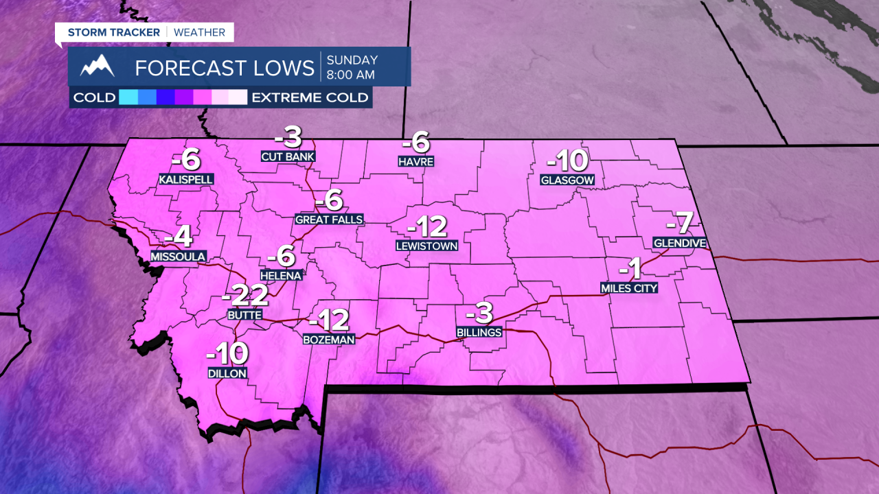
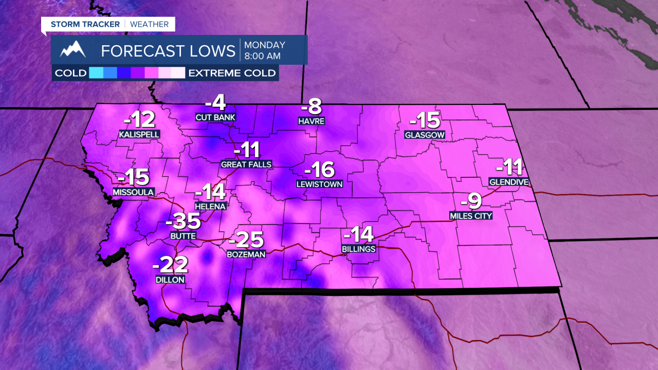
Deep cold Arctic air will begin to drop down into Montana Friday evening and as the snow ends and skies clear morning lows by Sunday morning will be well below zero. The coldest morning lows should be Monday morning and remaining well below zero through Tuesday morning.
Wind chills late weekend into next week could be colder than –30 below zero. Limit your exposure to the extreme cold as much as possible.
Travel is not recommended Friday through Saturday with the risk of low visibility and flash freezing.