


BOZEMAN – Latest model run continues to show widespread snow to impact most of the Montana and Idaho Wednesday evening through Friday morning.

A slow moving Low pressure system is digging into the Pacific NW and this storm will begin to drift into Montana tonight and reach SW Montana Thursday into Friday.
A cold front will bring the best chance for snow down into the valley floor Thursday afternoon through Thursday evening. This front will also produce gusty surface winds. That means areas of blowing and drifting snow is possible and reduced visibility creating hazardous travel conditions.
The storm should eject out of our region by late Friday morning. Behind the front colder air will move back in with below normal temperatures through the weekend and another shot of Arctic air arriving early next week.
There are numerous winter weather highlights up across the entire region over the next 48 hours. This means difficult to hazardous travel conditions and if you are traveling you need to be prepared for extreme winter conditions.
The National Weather Service issued a WINTER STORM WARNING across eastern Washington State, Idaho Panhandle, and over NW and West Central Montana now through midnight Thursday. Spokane, WA area could see 3”-10” of snow, Lookout Pass could see up to a foot of snow. Also watch for wind gusts 30 to 50 mph producing blowing and drifting snow.
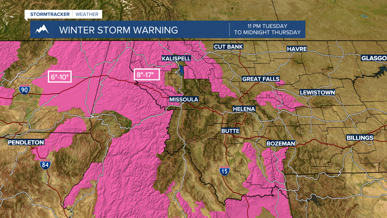
The National Weather Service issued a WINTER STORM WARNING for mountain ranges in Madison, Gallatin, and southern Beaverhead counties from midnight Wednesday to 5 pm Friday. Snow totals will vary from 5”-10” to the north but 1’ to 2’ of snow is possible around West Yellowstone and Island Park, ID. Wind gusts to 45 mph are possible and will produce blowing and drifting snow and poor visibility. I-15 Monida Pass on the Idaho side could see 8”-16” of snow considerable areas of blowing snow.

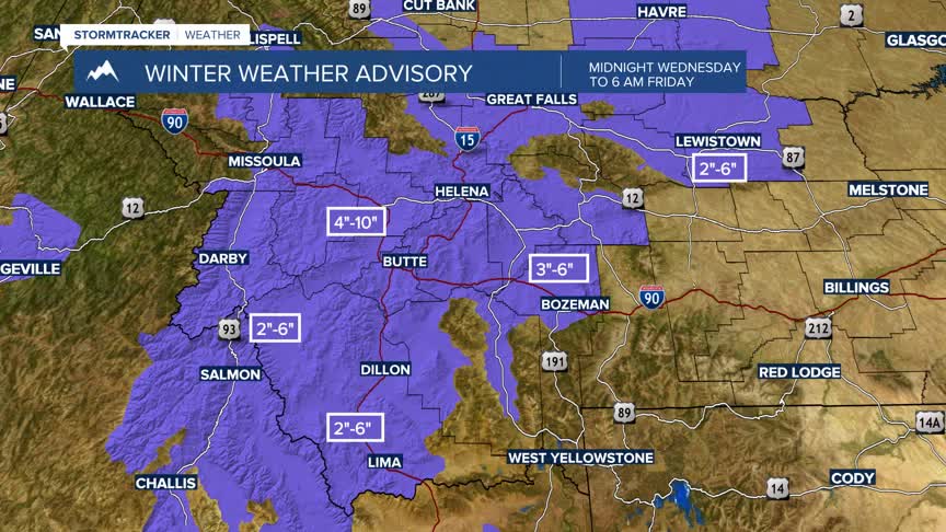
The National Weather Service issued a WINTER WEATHER ADVISORY for lower elevations across SW Montana midnight Wednesday to 6 am Friday. Snow totals will be widely varied between 2”-10”. A cold front will produce stronger wind gusts Thursday afternoon into Thursday evening and blowing snow is likely to impact Thursday evening commutes.

The National Weather Service has issued a WINTER STORM WATCH for the Absaroka-Beartooth range and Yellowstone National Park Wednesday afternoon through Friday afternoon. This watch will likely get upgraded to warning soon. Snow totals of 1’-2’ feet are possible along with considerable areas of blowing and drifting snow.

