


BOZEMAN – Severe winter weather will impact Montana and much of the northern half of the country through next week.
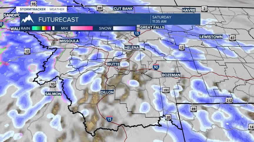
A large and stationary High-pressure ridge is parked off the NW coast. This is forcing the Polar Jet Stream to lift up into northern Canada and pull Arctic air down into Montana. There is also a fair amount of moisture in the N-NW flow aloft which will produce a long duration snow event beginning Thursday night and could linger through Sunday evening.

Snow will be heavy at times especially over most mountain passes and for a few lower valleys as well and thus there are numerous Watches, Warnings, and Advisories up across the state.
The National Weather Service has issued a WINTER WEATHER ADVISORY for Gallatin, Jefferson, Broadwater, Meagher counties of SW Montana and up into central and northern counties of Montana from 5 pm Thursday to 5 pm Sunday.
General snow accumulations: valleys 4”-10” and mountains and passes 10”-20” of snow.
Wind gusts 30 to 40 mph are possible and will produce areas of blowing snow and drifting snow along with wind chill values around -25° below zero.
Areas impacted: Bozeman, Bozeman pass, MacDonald pass, Homestake pass, Boulder, Boulder pass, Toston, Townsend, White Sulphur Springs, Kings Hill pass, Great Falls to Lewistown, Cut Bank to Havre.

______________________________________________________________________________________________________________________________
The National Weather Service has issued a WINTER STORM WATCH from Livingston to Billings to Miles City Thursday evening through Sunday evening. This will likely get upgraded to an advisory or warning soon.
General snow accumulations of 5”-10” is possible along with wind gusts 30 to 50 mph. That will produce areas of blowing and drifting snow along with wind chill values around -25° below zero.

___________________________________________________________________________________________________________________________
The National Weather Service has issued a WINTER STORM WARNING for the Absaroka-Beartooth and Crazy mountain ranges from 5 pm Thursday to 5 pm Sunday.
Snow accumulations of 1 to 2 feet are possible along with wind gusts 40 to 50 mph. Considerable blowing snow is likely at higher elevations and wind chill values colder than -30° below zero.
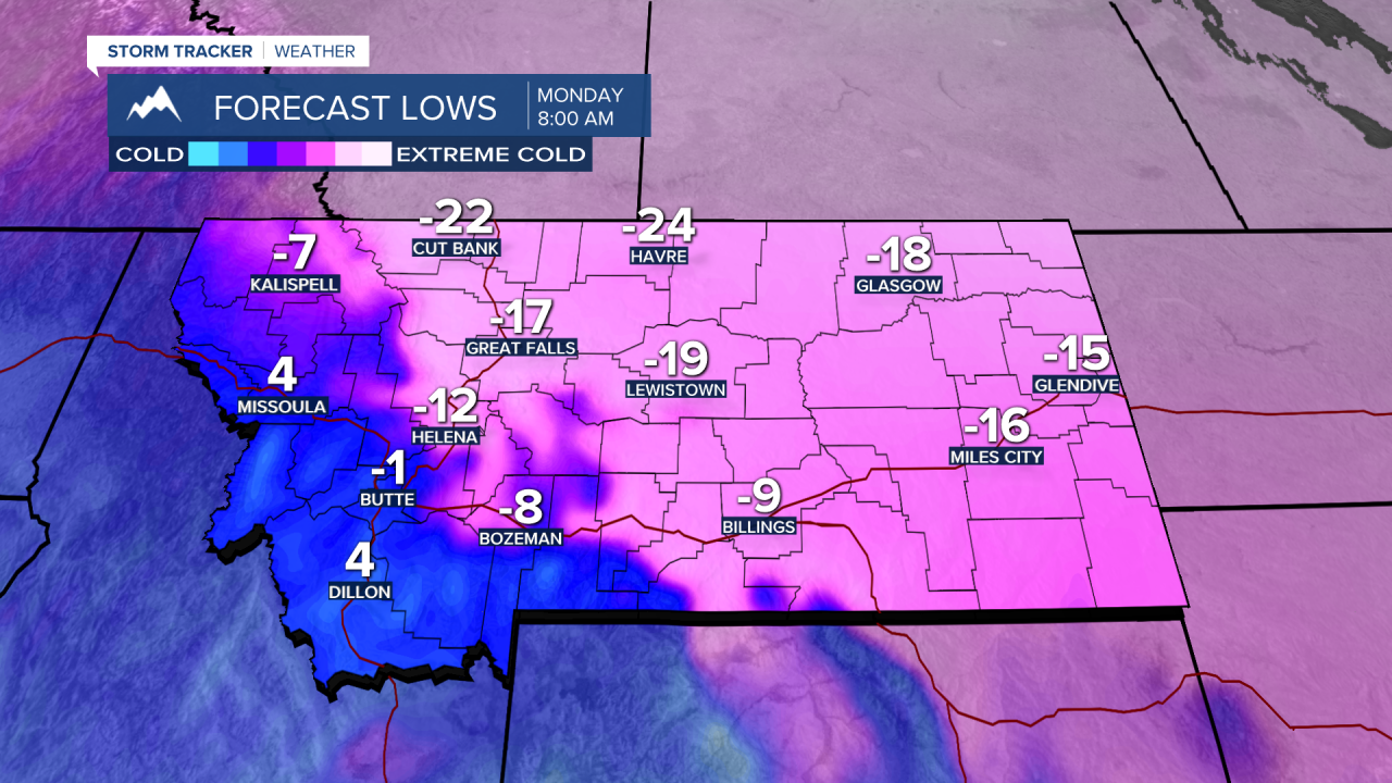
As the snow diminishes late Sunday cold Arctic air will deepen for many valleys across Montana. The coldest morning lows are likely Monday and Tuesday morning across the state and the coldest morning wind chill values.
Most areas east of the divide could see morning lows between -10° and -30° below zero especially for central, eastern and northern counties.


Forecast lows will begin to fall below zero as early as Saturday morning but plan on the coldest morning lows between Sunday and Tuesday morning. These forecast temperatures are updated frequently and most models have a difficult time narrowing down the extent of the cold, some are much colder than shown in the graphics below and others are slightly warmer than the graphic below. The forecast lows below are a mid-range. Look for updates here and on the STORMTracker Weather mobile app and of course frequent updates on KBZK and KXLF news casts.