Today's Forecast: Snow showers are expected to continue to blanket the area throughout the day. Scattered snow showers will continue through the afternoon and evening, though most of the snow showers are expected to become less dense after the noon hour. Highs will stay in the low 30s through the day which will likely leave icy roads for the evening with more snow expected overnight. Winds are expected to pick up out of the north or northeast between 10-20 mph which will compound visibility issues and leave wind chill values in the teens and 20s for most of the area.
BOZEMAN: High: 34; Low: 24. Scattered snow showers are expected to continue with between 3”-6” of snow in place by Tuesday morning. Winds will pick up late in the afternoon and early evening with snow tapering through the morning on Tuesday.
BUTTE: High: 32; Low: 19. Scattered snow showers will continue. Most of the latest model runs are showing between 1”-2” of snow with a few areas picking up 3” of snow by Tuesday morning before skies begin to clear.
DILLON: High: 31; Low: 23 Bands of snow will continue for your Monday with as much as 2”-4” possible by Tuesday.
WEST YELLOWSTONE: High: 36; Low: 19. A rain/snow mix will transition to all snow for the day today. We could pick up a hefty 6”-12” of snow by Monday evening for areas around West Yellowstone through the evening.
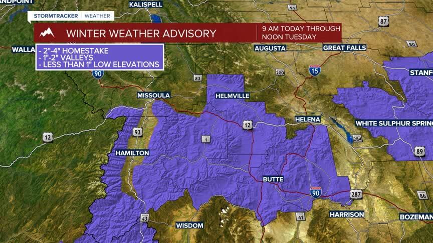
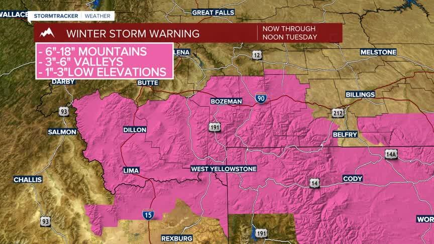
WINTER WEATHER HIGHLIGHTS:
Winter Storm Warning: Gallatin, Madison, and Beaverhead counties are under a winter storm warning through noon Tuesday. Expect 6”-18” of mountain snow, 3”-6” of valley snow, with lighter snow ranging from 1”-3” in low elevations. Watch for slick roads, slushy or icy conditions, and chilly temperatures compounded with chilly wind chills in the 20s.
Winter Weather Advisory: A Winter Weather Advisory has been issued for the Butte/Blackfoot region through noon Tuesday. Biggest impacts will be in the mountains and mountain passes with 1”-2” for valleys