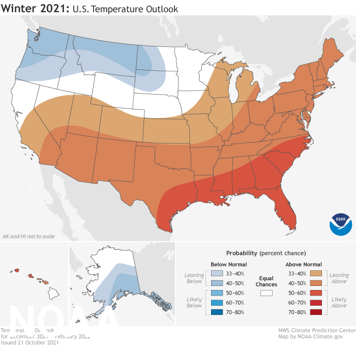
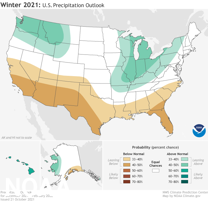
Above-average temperatures are favored across the South and most of the eastern U.S. as La Nina climate conditions have emerged for the second winter in a row according to NOAA’s Climate Prediction Center — a division of the National Weather Service. In NOAA’s 2021 Winter Outlook — which extends from December 2021 through February 2022 — wetter-than-average conditions are anticipated across portions of the Northern U.S., primarily in the Pacific Northwest, northern Rockies, Great Lakes, Ohio Valley and western Alaska.
“Using the most up-to-date observing technologies and computer models, our dedicated forecasters at the Climate Prediction Center produce timely and accurate seasonal outlooks to help communities prepare for the months ahead,” said Michael Farrar, Ph.D., director of the National Centers for Environmental Prediction.
Video highlights from NOAA's 2021-2022 Winter Outlook that provide seasonal predictions for temperature, precipitation and drought. This video and related map images can also be accessed online at www.climate.gov/WinterOutlook2021. (NOAA Climate.gov, based on NWS CPC data)
NOAA experts also continue to monitor the widespread, ongoing drought that has persisted across much of the western half of the U.S. since late last year, keeping a close eye on the Southwest region.
“Consistent with typical La Nina conditions during winter months, we anticipate below-normal temperatures along portions of the northern tier of the U.S. while much of the South experiences above-normal temperatures,” said Jon Gottschalck, chief, Operational Prediction Branch, NOAA’s Climate Prediction Center. “The Southwest will certainly remain a region of concern as we anticipate below-normal precipitation where drought conditions continue in most areas.”
This U.S. Winter Outlook 2021-2022 map for temperature shows warmer-than-average conditions across the South and most of the eastern U.S., while below average temperatures are favored for southeast Alaska and the Pacific Northwest eastward to the Northern Plains. (NOAA Climate.gov, using NWS CPC data)

Temperature
- Warmer-than-average conditions are most likely across the Southern tier of the U.S. and much of the Eastern U.S. with the greatest likelihood of above-average temperatures in the Southeast.
- Below-average temperatures are favored for southeast Alaska and the Pacific Northwest eastward to the northern Plains.
- The Upper Mississippi Valley and small areas of the Great Lakes have equal chances for below-, near- or above-average temperatures.
This 2021-2022 U.S. Winter Outlook map for precipitation shows wetter-than-average conditions are most likely in parts of the North, primarily in the Pacific Northwest, northern Rockies, Great Lakes, Ohio Valley and western Alaska. Drier-than-average conditions are favored in south-central Alaska, southern California, the Southwest, and the Southeast. (NOAA Climate.gov based on NWS CPC data)

Precipitation
- The Pacific Northwest, northern Rockies, Great Lakes and parts of the Ohio Valley and western Alaska have the greatest chances for wetter-than-average conditions.
- Drier-than-average conditions are favored in south-central Alaska, southern California, the Southwest, and the Southeast.
- The forecast for the remainder of the U.S. shows equal chances for below-, near- or above-average precipitation during winter months.
This seasonal U.S. Drought Outlook map for November 2021 through January 2022 predicts persistent drought across the West, Northern Plains, and the Missouri River Basin. Drought improvement is anticipated in the Pacific Northwest, northern California, the upper Midwest, and Hawaii. (NOAA Climate.gov based on NWS CPC data)

Drought
- Widespread severe to exceptional drought continues to dominate the western half of the continental U.S., Northern Plains, and the Missouri River Basin.
- Drought conditions are forecast to persist and develop in the Southwest and Southern Plains.
- The Pacific Northwest, northern California, the upper Midwest, and Hawaii are most likely to experience drought improvement.
About NOAA's seasonal outlooks
NOAA’s seasonal outlooks provide the likelihood that temperatures and total precipitation amounts will be above-, near- or below-average, and how drought conditions are anticipated to change in the months ahead. The outlook does not project seasonal snowfall accumulations as snow forecasts are generally not predictable more than a week in advance.
NOAA’s Climate Prediction Center updates the three-month outlook each month. The next update will be available November 19.
Seasonal outlooks help communities prepare for what is likely to come in the months ahead and minimize weather's impacts on lives and livelihoods. Empowering people with actionable forecasts and winter weather tips is key to NOAA’s effort to build a more Weather-Ready Nation.


