


BOZEMAN – Caution! Active winter weather ahead and it will have a big impact on local travel conditions.
The combination of powerful wind gusts along with periods of snow will produce blowing snow and low visibility travel hazards Thursday evening into Friday morning. The strongest peak gusts should be along the cold front and begin to diminish by Friday afternoon.
A broad trough of Low-pressure will slowly dig into the western half of the country and keep Montana in a cold and unsettled pattern Friday through Sunday. Periods of off and on snow and colder than normal temperatures will create difficult travel conditions.

The National Weather Service has issued WINTER WEATHER ADVISORIES for SW Montana west of the divide from 6 pm Thursday to 9 am Friday for the Butte-Blackfoot region.
Snow accumulations of 1”-3” for lower valleys and 3”-6” for mountains and passes. Peak wind gusts 60 to 70 mph combined with the fallen snow and snow on the ground will produce areas of blowing snow and low visibility.
The National Weather Service issued a WINTER WEATHER ADVISORY for SW Montana east of the divide mountains and passes in Beaverhead, Madison, and Gallatin Counties from 5 pm Thursday to 5 pm Friday.
Snow accumulations of 2”-6” with over a foot of higher mountain snow is possible out of this storm. Again, combined with peak wind gusts 60 to 70 mph will produce areas of blowing snow and very low visibility travel hazards. One area for the greatest concern will be along the MT/ID state line.
The National Weather Service issued a WINTER STORM WARNING now through 11 pm Saturday across Eastern Idaho, Western Wyoming and up into the Absaroka-Beartooth range near Cooke City, MT.
Mountain snow between 1’ to 3’ feet is possible with 4”-10”+ for lower valleys is possible. Peak wind gusts up to or over 60 mph will create considerable areas of blowing and drifting snow creating dangerous travel conditions and very dangerous backcountry conditions.

The National Weather Service continues a HIGH WIND WARNING across most of SW Montana (does not include Bozeman or Belgrade) through 4 am Friday morning. A WIND ADVISORY is also up for the Livingston area.
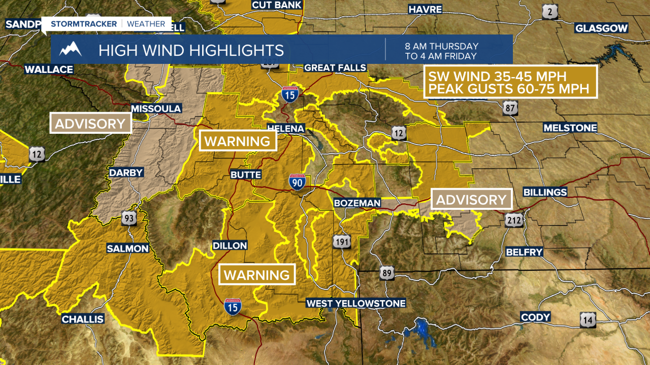
Sustained wind in most areas will be 30 to 40 mph and peak gusts up to 60 to 75 mph are possible. This could produce property damage and could produce localized power outages.
