Active weather pattern will begin to impact Montana tonight and continue into the weekend.
WHAT YOU NEED TO KNOW:
- Morning commutes will be icy Thursday over mountain passes but valleys and mountain passes by Friday morning
- Colder air is digging down into Montana through Friday
- Numerous storms will hit Montana over the next 7 to 10 days
- Mixed precipitation is possible at times during the warmer afternoon hours
- Check the STORMTracker Travel Watch Page before hitting the road: Click Here
The above on demand STORMTracker video will walk you through the forecast hour by hour through Friday and cover travel concerns for Bozeman and SW Montana with Chief Meteorologist Mike Heard.
UPDATE:
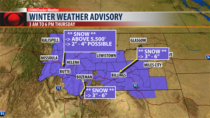
The National Weather Service has issued a WINTER WEATHER ADVISORY for the Butte/Blackfoot region from 3 am to 6 pm Thursday.
Snow accumulations above 5,500′ are likely with 2" – 4" possible and higher mountain passes could see up to 9"
A WINTER WEATHER ADVISORY is also up for South Central Montana Thursday.
Areas impacted: Livingston to Billing to Miles City.
Snow accumulations of 3" – 6" is possible and wintry travel impacts likely.
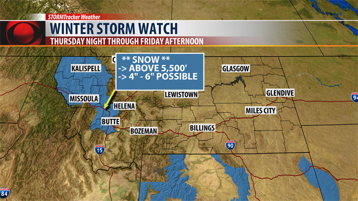
National Weather Service has issued a WINTER STORM WATCH for Thursday evening into Friday afternoon for areas west of the divide including the Butte/Blackfoot region.
Snow above 5,000′ is likely with 4" – 6" possible and up to 9" at higher mountain passes.
Strong NE winds 15 to 35 mph are possible and could produce localized blowing snow and reduced visibility.

Colder Canadian air will be digging down into Montana Thursday into Friday impacting Northern and Eastern Montana and keeping temperatures in SW Montana slightly cooler than normal.
Rain changing to snow in the overnight hours will bring wintry travel concerns to the state Thursday and Friday.

Above is a look at potential snow accumulations that could impact SW Montana Thursday through early Saturday morning.
Early morning hours on Friday has the best chance for snow to stick at all levels and create snow covered and icy roads for your Friday morning commute.
Temperatures should warm up enough to thaw roadways Friday afternoon and by Saturday most valleys should see mainly rain but mountains and passes could see additional snowfall throughout the weekend.
So please be prepared for longer commute times Friday morning.
Micro Climates Next 24 Hours:
BOZEMAN: Low: 30, High: 39. Mostly cloudy with scattered rain or snow for lower valleys and snow is likely above 6,000′ with 1" – 3" possible at pass level. Winds should be light around 5 to 15 mph this evening but could increase 10 to 20 mph by Thursday afternoon.
BUTTE: Low: 28, High: 41. Scattered rain changing to snow overnight and continue throughout the day Thursday. Snow levels 5,500′ with 1" – 3" possible. Watch for increasing NE winds Thursday 15 to 25 mph.
DILLON: Low: 32, High: 50. Mostly cloudy with a few rain or snow showers. Snow levels 6,500′ with 1" – 2" possible by morning.
WEST YELLOWSTONE: Low: 22, High: 42. Scattered snow showers with minor accumulations of 1" – 3". West Winds to 15 mph
WEEKEND WEATHER PATTERN: Cool and wet. Scattered valley rain could mix with a little snow and there could be a few isolated thunderstorms Saturday night. Minor snow accumulations are possible for valley floors Sunday morning but be prepared for slushy snow accumulations over mountain passes this weekend.
RELATED LINKS:
| Interactive Radar | Doppler Radar |
| 7-Day Forecast | Snow Report |
| Current Temperatures | Current MT Temperatures |
| Weather Cameras |
