The above on demand STORMTracker Weather video will focus on the threat for flooding across SW Montana through the rest of this week into the long Memorial Day Weekend with Chief Meteorologist Mike Heard.
Below are the supporting graphics used in today’s flood briefing.
FLOOD BRIEFING
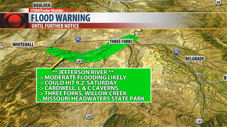
JEFFERSON RIVER
The National Weather Service has issued a FLOOD WARNING for the Jefferson River near Three Forks until Monday morning.
Water level rises will continue through the rest of this week into the weekend.
Minor flooding is occurring.
Moderate flooding is likely by Thursday.
** MAJOR flooding is possible by Friday night. **
Forecast river levels could hit 9.2’ by Saturday evening. Minor flood stage is 8’, Moderate flood stage is 8.5’ and Major flood stage is 9’.
Snowmelt of mountain snowpack along with daily rainfall is significantly increasing river level activity in SW Montana.
Water levels could rise higher than predicted if significant rainfall occurs along the Jefferson River Basing. For example, the flash flooding that hit Willow Creek from a slow moving thunderstorm producing heavy rainfall washed into the Jefferson River.
If you live along any river system in SW Montana please be prepared to take immediate action over the next 10 days if floodwaters threaten your life, property and/or livestock.
Areas of concern: Three Forks, Trident, Willow Creek, Cardwell, Lewis & Clark Caverns State Park and Missouri Headwaters State Park.
** TURN AROUND DON’T DROWN!
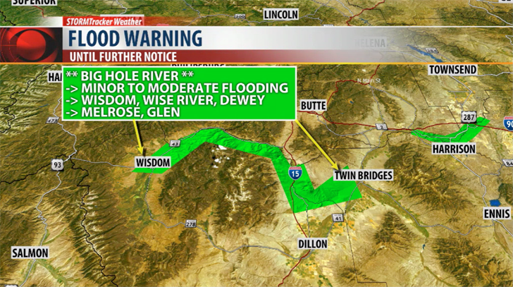
BIG HOLE RIVER
The National Weather Service has issued a FLOOD WARNING for the entire stretch of the Big Hole River through Sunday.
Water levels on the Big Hole River are holding just above minor flood stage for the last couple of days.
Additional river level rises are expected as we continue to see snowmelt along with daily thunderstorms.
The river is predicted to continue to rise to 7.6’ by Thursday night.
Minor flood stage is 6’, Moderate flood stage is 7.5’ and Major flood stage is 8’.
Significant agricultural land flooding is likely.
If you live along the Big Hole River be prepared to take immediate action if floodwaters threaten your life, property and/or livestock.
Areas of concern: Wisdom, Wise River, Dewey, Melrose and Glen.
** TURN AROUND DON’T DROWN!

The National Weather Service has issued a FLOOD WATCH for South Central Montana counties Tuesday night through Thursday morning.
Forecast models are estimating between a half inch up to 2 inches of rainfall in this area. If that occurs then there is a very good chance for flooding to develop especially along rivers and streams but there is a slight chance for localized flash flooding as well.
A Flood Watch means there is a potential for flooding based on current forecasts and those in the watch area should monitor the weather closely especially if you live in a flood prone area.
PRECIPITATION FORECAST
The next 5 to 10 days could be very wet according to various short range and medium range weather models. All models are showing a high probability of moderate to heavy rain across Montana.
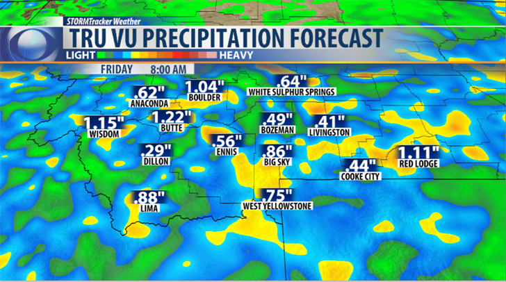
The above short range model shows a quarter of an inch up to 1" of moisture is possible now through Friday. The best chance for moderate to heavy rain will come in the form of afternoon thunderstorms Tuesday but wrap around moisture from a Low pressure system moving into Eastern Montana could bring moderate rainfall Wednesday morning and scattered showers through Wednesday afternoon.
Flash flooding is a concern over the next 24 hours with slow moving thunderstorms (Willow Creek experienced flash flooding Monday) and with wrap around moisture Wednesday morning.
A weaker disturbance arrives Thursday but keeps a chance for scattered showers and thunderstorms alive which will likely bring more flooding issues.
Temperature are likely to jump up into the 70s and possibly low 80s by Saturday.
All the above factors will enhance snowmelt runoff and keep all area rivers and streams near flood stage and possible reaching moderate to major flood stages by the weekend.

The above graphic is a medium range forecast model (ECMWF) through Memorial Day. Areas in yellow and red could see 1" plus through early next week. Again models showing a high probability of moderate to heavy rain over the next 7 to 10 days and this is why National Weather Service Hydrologists are concerned for area flooding issues for SW Montana.
MONITOR THE FORECAST AND CHANGES
Best tools to stay in the weather loop is to download the KBZK STORMTracker Weather Mobile app. You will get on demand STORMTracker video forecast updates on all flooding issues for your area, instant updates on all National Weather Service flood highlights like Advisories, Watches and Warnings and the best reason of all you will have access to the only local team of Meteorologists that live in SW Montana from the KBZK Weather Center in Bozeman.