A quiet weather pattern is building over SW Montana through the end of the week. There is a slight chance for a few isolated showers or weak thunderstorms during the afternoon hours Thursday and Friday.
The big news of the day is a statewide flood emergency was declared by Governor Bullock. CLICK HERE for the full story.
If you live in a flood prone area along any stream or major river you should be preparing now for possible flooding in the next couple of weeks.
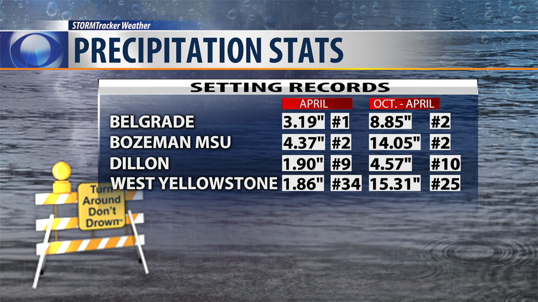
The National Weather Service is reporting impressive precipitation for the month of April in SW Montana east of the divide and a few of us set records. See the data in the above on demand STORMTracker video forecast with Chief Meteorologist Mike Heard.
City by City Forecast:
BOZEMAN: LOW: 36°; HIGH WEDNESDAY: 64°. Partly cloudy tonight and cool with light winds, Thursday should be mostly sunny and mild with light winds.
BUTTE: LOW: 30°; HIGH WEDNESDAY: 63°. Mostly clear and chilly tonight with light winds and Thursday looks good with mostly sunny skies and mild with light winds.
DILLON: LOW: 32°; HIGH WEDNESDAY: 65°. Mostly dry over the next 24 hours, clear and cool tonight and sunny and mild Thursday.
WEST YELLOWSTONE: LOW: 24°; HIGH WEDNESDAY: 54°. Frosty overnight with clearing skies and light winds. Thursday slow to warm up but eventually reaching the mid 50s.
Next Week:
Forecast models continue to point toward a warming trend next week and possibly reaching the upper 70s to lower 80s by the end of next week. That might sound wonderful but it will likely lead to rapid snow melting and increased water flows on streams, creeks and major river systems. Increased flooding is likely through the rest of May and possibly into early June.
