Another powerful storm will bring wintry weather back to most of Montana Wednesday night through Friday morning.

The National Weather Service has a WINTER STORM WATCH up for most of SW, Central and Southern Montana counties Wednesday night through Friday morning and across Northern Wyoming into South Dakota. This includes I-90, I-15 and I-94.
Winter Storm Watch is issued well in advance of powerful storms to give you time to prepare and plan accordingly. Look for this Watch to be upgraded most likely to a WINTER STORM WARNING over the next 24 hours. Keep in mind that if a WINTER STORM WARNING issued for your area it means the storm will be life threatening so take it seriously.

Breaking it down by region: Madison, Gallatin and Broadwater counties are under a WINTER STORM WATCH Wednesday night through Friday morning.
Snow accumulations: Valleys 2" – 8" possible with Mountains 8" – 16"
Snow levels will start off Thursday around 6,000′ but will drop down to the valley floor Thursday afternoon through Friday morning. Temperatures will fall well below freezing Friday morning setting up extreme icing on area roads at all levels for your Friday morning commute.
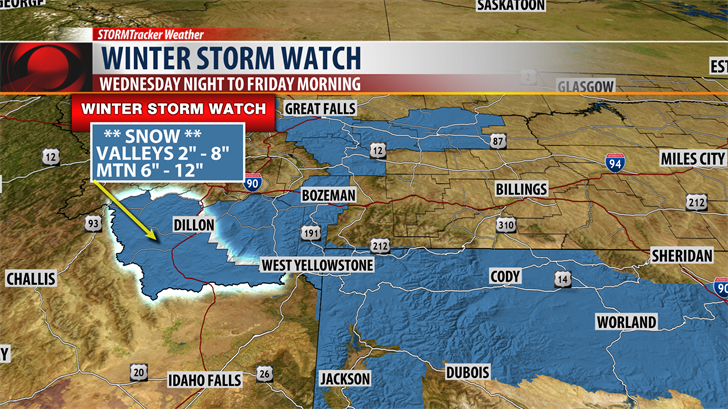
Beaverhead county is also under a WINTER STORM WATCH Wednesday night through Friday morning.
Snow accumulations of 2" – 8" likely for most valleys but Dillon lesser accumulations of 1" – 3" is possible. Mountains and passes could see 6" – 12" of snow and that includes Monida Pass on I-15 and Big Hole Pass on State Highway 278.

Yellowstone National Park is under a WINTER STORM WATCH Wednesday night through Friday morning.
Snow accumulations of 8" – 12" is most likely with some ranges in the park picking up to 2′ (feet) of snow.
INSIDE THE FORECAST:
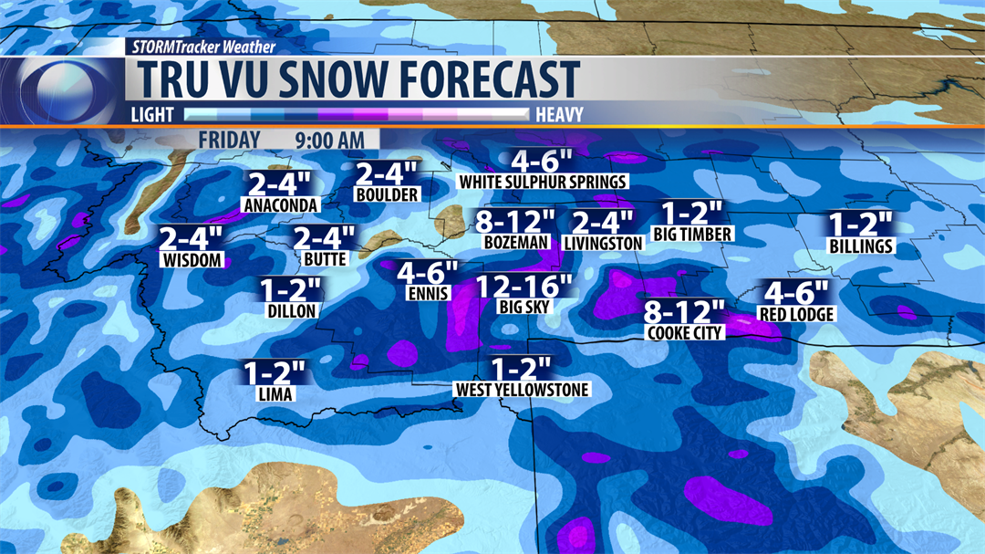
Our higher resolution forecast models are estimating some impressive snow totals. Keep in mind this is just model guidance and actual snow totals will vary greatly from model output.
Areas west of the divide will see snow in the Butte, Anaconda, Deer Lodge areas and possible higher amounts near Georgetown Lake and MacDonald Pass.
Travel impacts are likely especially Friday morning as temperatures fall well below freezing.
East of the divide models are projecting heavier snow total especially for Madison and Gallatin counties. Travel impacts are likely and at times travel may become impossible over Bozeman Pass on I-90 Thursday afternoon through Friday morning.
We are anticipating heavy wet snow with slushy accumulations Thursday afternoon which will freeze Thursday night and more snow on top of the ice could lead to extreme travel impacts Friday morning.

A rain/snow mix is possible Wednesday night into Thursday morning but mostly snow Thursday into Friday morning.
The above model shows possible total moisture. If we end up with an inch or more of water content look for some runoff issues and possible minor flooding Friday into the weekend.
Temperatures will warm up enough Friday afternoon into the weekend to rapidly melt off lower elevation snow. With the ground fairly saturated right now there could be some runoff issues this weekend.
During these high impact events my best advise to all of you is keep informed on the latest forecasts and the best way to do that is through the STORMTracker Weather Mobile app. It’s Free! You will get direct forecasts from the only team of Meteorologists that live, work and play in SW Montana from our Bozeman station.